Tolls . Fuel . Trip Optimization

Fleets, OEMs, and rideshares use TollGuru for pre-trip cost and time trade-offs, on-trip toll rate alerts, and post-trip toll billing. Looking to 
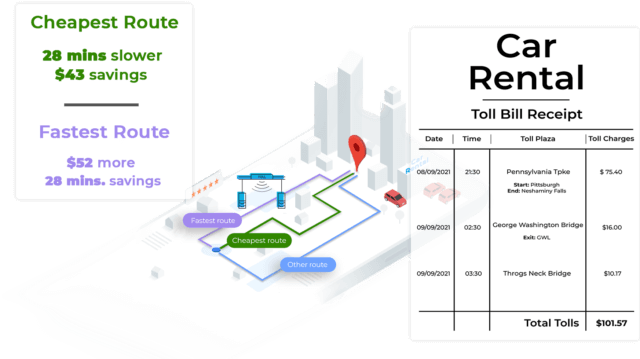
Bill for trip tolls immediately?

Add tolls to your map?

Travel on cost-optimized routes?

TollGuru-toll-intelligence
Lyft
Dunavant
Honk
iCan Storage
Vehicle Tracking System
Airspace
Getaround
Qudos
Kuehne
FidelisFreight
Kapsch
Lyft
Dunavant
Honk
iCan Storage
Vehicle Tracking System
Airspace
Getaround
Qudos
Kuehne
FidelisFreight
Kapsch

Global Toll Solution

The only comprehensive toll platform that covers all toll plazas on highways, turnpikes, motorways, expressways, tunnels, and bridges. Covering toll agency-specific toll information such as vehicle classes, payment options, discounts, toll tags, and passes.

If it’s toll, it’s TollGuru!

TollGuru Covergae Map
45+-countries

80+

Countries

highway

30,990,127+

Miles of highways

3500+-API-integration

3,500+

API integrations

3M-users

4 Mn+

User community

Integrate Toll APIs in Minutes

From pre-trip, on-trip, to post-trip, TollGuru Toll APIs make your business cost intelligent. Integrate to see costs - tolls, fuel expenses, driver charges, and others - for any route. Know the cheapest, the fastest, and compromise routes. Send GPS tracks or route polylines and accurately bill customers immediately.
supports-all-maps

Supports all maps

Map independent integration with Google, Bing, MapBox, Apple Map, HERE, TomTom etc. or any other custom map
Learn more >

language-libraries

Language libraries

Client libraries in Java, Python, Go, Node.js, PHP, Ruby, .NET, and other languages to quickly integrate Toll API

Explore libraries >

{
    "status": "OK",
    "summary": {
        "route": [
            {
                "location": {
                    "lat": 41.15673,
                    "lng": -73.92859
                },
                "address": "135 N Route 9W, Congers, NY 10920, United States"
            },
            {
                "location": {
                    "lat": 41.13378,
                    "lng": -74.1277
                },
                "address": "14 Zeck Ct, Suffern, NY 10901, United States"
            }
        ],
        "rates": {
            "USD": 1,
            "CAD": 1.240355,
            "MXN": 19.95004,
            "INR": 74.430214,
            "AUD": 1.335256,
            "GBP": 0.723775,
            "EUR": 0.843846,
            "NOK": 8.615545,
            "SEK": 8.55675,
            "DKK": 6.27543,
            "PEN": 6.27543,
            "COP": 6.27543,
            "ARS": 6.27543,
            "CLF": 6.27543,
            "CLP": 6.27543,
            "HUF": 296.570972,
            "BAM": 1.645643,
            "HRK": 6.323596,
            "ISK": 123.805413,
            "PLN": 3.817765,
            "RON": 4.155019,
            "RSD": 98.953294,
            "CHF": 0.925885,
            "ALL": 102.949717,
            "BYN": 2.532794,
            "BGN": 1.650695,
            "CZK": 21.521503,
            "MDL": 18.029137,
            "MKD": 51.956101,
            "RUB": 73.239502,
            "SOL": 6.27543
        },
        "currency": "USD",
        "countries": [
            "USA"
        ],
        "departure_time": 1625137683,
        "fuelPrice": {
            "value": 2.79,
            "currency": "USD",
            "fuelUnit": "gallon"
        },
        "fuelEfficiency": {
            "city": 24,
            "hwy": 30,
            "units": "mpg"
        },
        "vehicleType": "2AxlesAuto",
        "share": {
            "name": "congers,ny-suffern,ny",
            "prefix": "congers%2Cny-suffern%2Cny",
            "uuid": "4e984228-8074-4e87-bcff-4964198b9260"
        },
        "source": "HERE",
        "units": {
            "currencyUnit": "USD",
            "fuelEfficiencyUnit": {
                "city": 24,
                "hwy": 30,
                "units": "mpg",
                "fuelUnit": "gallon"
            }
        }
    },
    "routes": [
        {
            "summary": {
                "hasTolls": false,
                "hasExpressTolls": false,
                "diffs": {
                    "cheapest": 0,
                    "fastest": 4
                },
                "url": "https://www.google.com/maps/?saddr=41.1567413,-73.9287596&daddr=41.1564267,-73.9280319+to:41.1685717,-73.9389002+to:41.1972392,-73.9753139+to:41.1335957,-74.1277492&via=1,2,3",
                "distance": {
                    "text": "14.7 mi",
                    "metric": "23.6 km",
                    "value": 23585
                },
                "duration": {
                    "text": "30 min",
                    "value": 1836
                },
                "name": "US-202",
                "note": []
            },
            "driver": {
                "billedHours": 0.75,
                "wage": 30,
                "total": 22.5
            },
            "costs": {
                "fuel": 1.55
            },
            "tolls": [],
            "directions": [
                {
                    "position": {
                        "latitude": 41.1567413,
                        "longitude": -73.9287596
                    },
                    "maneuver": "forward",
                    "html_instructions": "Head toward <span class="toward_street">N US-9W</span>. <span class="distance-description">Go for <span class="length">295 ft</span>.</span>",
                    "distance": 90,
                    "duration": 54,
                    "note": [
                        {
                            "type": "restriction",
                            "code": "privateRoad",
                            "text": "Private road"
                        }
                    ]
                },
                {
                    "position": {
                        "latitude": 41.1564267,
                        "longitude": -73.9280319
                    },
                    "maneuver": "left",
                    "html_instructions": "Turn <span class="direction">left</span> onto <span class="next-street">N US-9W</span> <span class="number">(US-9W)</span>. <span class="distance-description">Go for <span class="length">1.1 mi</span>.</span>",
                    "distance": 1742,
                    "duration": 153,
                    "note": []
                },
                {
                    "position": {
                        "latitude": 41.1685717,
                        "longitude": -73.9389002
                    },
                    "maneuver": "right",
                    "html_instructions": "Turn <span class="direction">right</span> onto <span class="next-street">N US-9W</span> <span class="number">(US-9W)</span>. <span class="distance-description">Go for <span class="length">3.0 mi</span>.</span>",
                    "distance": 4900,
                    "duration": 353,
                    "note": []
                },
                {
                    "position": {
                        "latitude": 41.1972392,
                        "longitude": -73.9753139
                    },
                    "maneuver": "left",
                    "html_instructions": "Turn <span class="direction">left</span> onto <span class="next-street">Westside Ave</span> <span class="number">(US-202)</span>. <span class="distance-description">Go for <span class="length">10.3 mi</span>.</span>",
                    "distance": 16496,
                    "duration": 1116,
                    "note": []
                },
                {
                    "position": {
                        "latitude": 41.1339605,
                        "longitude": -74.1309249
                    },
                    "maneuver": "left",
                    "html_instructions": "Turn <span class="direction">left</span> onto <span class="next-street">Mayer Dr</span>. <span class="distance-description">Go for <span class="length">0.1 mi</span>.</span>",
                    "distance": 185,
                    "duration": 41,
                    "note": []
                },
                {
                    "position": {
                        "latitude": 41.1328769,
                        "longitude": -74.1292405
                    },
                    "maneuver": "left",
                    "html_instructions": "Turn <span class="direction">left</span> onto <span class="next-street">Henry Ct</span>. <span class="distance-description">Go for <span class="length">443 ft</span>.</span>",
                    "distance": 135,
                    "duration": 22,
                    "note": []
                },
                {
                    "position": {
                        "latitude": 41.1337566,
                        "longitude": -74.1281354
                    },
                    "maneuver": "right",
                    "html_instructions": "Turn <span class="direction">right</span> onto <span class="next-street">Zeck Ct</span>. <span class="distance-description">Go for <span class="length">121 ft</span>.</span>",
                    "distance": 37,
                    "duration": 5,
                    "note": []
                },
                {
                    "position": {
                        "latitude": 41.1335957,
                        "longitude": -74.1277492
                    },
                    "maneuver": "forward",
                    "html_instructions": "Arrive at <span class="street">Zeck Ct</span>. Your destination is on the left.",
                    "distance": 0,
                    "duration": 0,
                    "note": []
                }
            ],
            "polyline": "slezFvefbMf@BNMDgCcICwD@}@H{@T{@iHzDkAp@sBdAsJxFi@d@{@bAy@pAgBfCe@v@oDhF]n@o@vAwBpGkChIYfAa@`C}B~@mCzA{AbAYVk@|@Q`@YnAMrBDfCLbDAhBMhAa@dBg@~@WZqC|Bc@Tq@To@Pi@Dm@Ae@Em@Ui@a@QUQYkB}Di@o@o@e@_@So@Wm@O}@E]B[Fa@Pe@Zi@j@u@~@UwBrD}@fBo@xAuAfEiBnI_AdCsCvEi@lAYr@wB|GcAzDs@hC[j@c@j@gNdNaCfCcDfDyHhIoGxGqGpFeAhAgCtDwA|BmAtB}HpNeBtCeF`J_@|@YdAMr@}@jEgClJo@lCV|@Lx@^fFPrAFjADlAE`BEx@G`@[xAcFxQi@xA{AjDiA`D{AvDuBnD[n@Mb@WrAi@lD[rAo@xBqD`NUlAEn@MpD@tABb@Np@Vz@v@hBt@nBVrAZpENdDNdCTxEB~@@rGF`BDz@f@|FNzBVvCzAhJXjAvCnKj@lARZX`@f@f@|@l@z@jBh@|Af@rCfBfBlAlDjCt@v@V^h@dAn@hBhAdGZnAj@vAl@t@bAxCvCr@~@^t@n@fBbAdEh@xA|ArDPl@Pt@PjADlAFjGRnCNz@Fh@Lr@vAhG`CrHjFbMd@rAZvARxAHvAB|ADxLHlBn@xHHj@~A`Ov@rF?LzBxBjL^dBtBxIx@vDtA|FjBfHp@~Cj@bDT~B^jFHrC@jEKxEKfBOjBm@xEoBxK[pBSbBYhDQlECpBD`EF~AHxAZpDj@hELj@^dBh@nBnAbDh@hAdAlBbGbKxArCv@rBx@hCb@hBd@fCx@lDXbAf@xAn@zAv@bBz@|A|MfSx@`AdA|@b@VdAd@fCbAjAl@jAr@jA`A|A`Bj@p@jApBVl@^`BZpCJlAfD`BVz@vAtCr@z@`Ax@f@XjFzBzA`A|CtC~MtMrIdIv@n@tKlI`BxAfI~I|@x@xAlAfAr@vGjDjAv@~@t@xApA|BtBf@`@lPbOnD~CxBrBpJjKxEbFtHrHp@l@xDpDvAlA~E~En@|@Xj@Vj@|@nCr@`Bl@dAlDzEbG`If@z@Vh@b@nAT~@Ln@TfBFjA@r@BlKD~@J~@RpAZrA`AjCfB`E|@|B|BlFj@jAn@dAnBpCvBzBvBiE~AeCoD{E^mA"
        },
        {
            "summary": {
                "hasTolls": true,
                "hasExpressTolls": false,
                "diffs": {
                    "cheapest": null,
                    "fastest": 0
                },
                "url": "https://www.google.com/maps/?saddr=41.1567413,-73.9287596&daddr=41.1567413,-73.9287596+to:41.1564267,-73.9280319+to:41.1183822,-73.9415503+to:41.1023641,-73.9522469+to:41.1019135,-73.9543283+to:41.1306131,-74.1242838+to:41.1335957,-74.1277492&via=1,2,3,4,5,6",
                "distance": {
                    "text": "15.3 mi",
                    "metric": "24.5 km",
                    "value": 24545
                },
                "duration": {
                    "text": "27 min",
                    "value": 1624
                },
                "name": "I-87",
                "note": []
            },
            "driver": {
                "billedHours": 0.5,
                "wage": 30,
                "total": 15
            },
            "costs": {
                "fuel": 1.54,
                "tag": null,
                "cash": null,
                "licensePlate": null,
                "creditCard": null,
                "prepaidCard": null
            },
            "tolls": [
                {
                    "id": 1100216,
                    "lat": 41.09835,
                    "lng": -74.05465,
                    "name": "Spring Valley Toll Barrier",
                    "road": "New York State Thruway",
                    "state": "New York",
                    "country": "USA",
                    "type": "barrier",
                    "tagCost": 0,
                    "tagPriCost": 0,
                    "tagSecCost": 0,
                    "cashCost": null,
                    "licensePlateCost": 0,
                    "prepaidCardCost": 0,
                    "creditCardCost": null,
                    "currency": "USD",
                    "tagPrimary": [
                        "E-ZPass NY"
                    ],
                    "tagSecondary": [
                        "E-ZPass",
                        "E-ZPass DE",
                        "Uni",
                        "I-Pass",
                        "E-ZPass Skyway",
                        "E-ZPass IN",
                        "RiverLink",
                        "E-ZPass ME",
                        "E-ZPass MD",
                        "E-ZPass MA",
                        "E-ZPass NH",
                        "E-ZPass NJ",
                        "E-ZPass NC",
                        "E-ZPass OH",
                        "E-ZPass PA",
                        "E-ZPass RI",
                        "E-ZPass VA",
                        "E-ZPass WV",
                        "E-Zpass Flex"
                    ],
                    "licensePlatePrimary": "Tolls by Mail",
                    "discountCarDetails": null,
                    "discountCarType": null,
                    "height": 7.5,
                    "tagRequested": "prepaidCardCost",
                    "arrival": {
                        "distance": 16139,
                        "time": "2021-07-01T11:25:10+00:00"
                    },
                    "point": {
                        "type": "Feature",
                        "properties": {},
                        "geometry": {
                            "type": "Point",
                            "coordinates": [
                                -74.05465,
                                41.09835
                            ]
                        }
                    }
                }
            ],
            "directions": [
                {
                    "position": {
                        "latitude": 41.1567413,
                        "longitude": -73.9287596
                    },
                    "maneuver": "forward",
                    "html_instructions": "Head toward <span class="toward_street">N US-9W</span>. <span class="distance-description">Go for <span class="length">295 ft</span>.</span>",
                    "distance": 90,
                    "duration": 41,
                    "note": [
                        {
                            "type": "restriction",
                            "code": "privateRoad",
                            "text": "Private road"
                        }
                    ]
                },
                {
                    "position": {
                        "latitude": 41.1564267,
                        "longitude": -73.9280319
                    },
                    "maneuver": "right",
                    "html_instructions": "Turn <span class="direction">right</span> onto <span class="next-street">N US-9W</span> <span class="number">(US-9W)</span>. <span class="distance-description">Go for <span class="length">1.9 mi</span>.</span>",
                    "distance": 3100,
                    "duration": 209,
                    "note": []
                },
                {
                    "position": {
                        "latitude": 41.1302054,
                        "longitude": -73.9251244
                    },
                    "maneuver": "right",
                    "html_instructions": "Turn <span class="direction">right</span> onto <span class="next-street">Lake Rd</span>. <span class="distance-description">Go for <span class="length">1.2 mi</span>.</span>",
                    "distance": 2007,
                    "duration": 223,
                    "note": []
                },
                {
                    "position": {
                        "latitude": 41.1183822,
                        "longitude": -73.9415503
                    },
                    "maneuver": "left",
                    "html_instructions": "Turn <span class="direction">left</span> onto <span class="next-street">Route 303</span> <span class="number">(RT-303)</span>. <span class="distance-description">Go for <span class="length">1.3 mi</span>.</span>",
                    "distance": 2037,
                    "duration": 150,
                    "note": []
                },
                {
                    "position": {
                        "latitude": 41.1023641,
                        "longitude": -73.9522469
                    },
                    "maneuver": "right",
                    "html_instructions": "Turn <span class="direction">right</span> onto <span class="next-street">N Palisades Center Dr</span>. <span class="distance-description">Go for <span class="length">0.1 mi</span>.</span>",
                    "distance": 184,
                    "duration": 41,
                    "note": []
                },
                {
                    "position": {
                        "latitude": 41.1019135,
                        "longitude": -73.9543283
                    },
                    "maneuver": "left",
                    "html_instructions": "Turn <span class="direction">left</span> and take ramp onto <span class="number">I-87 N/I-287 W</span> <span class="next-street">(New York State Thruway N)</span>. <span class="distance-description">Go for <span class="length">8.4 mi</span>.</span>",
                    "distance": 13593,
                    "duration": 565,
                    "note": []
                },
                {
                    "position": {
                        "latitude": 41.1151958,
                        "longitude": -74.1070426
                    },
                    "maneuver": "bearRight",
                    "html_instructions": "Take exit <span class="exit">14B</span> toward <span class="sign"><span lang="en">Airmont Rd</span>/<span lang="en">Airmont</span>/<span lang="en">Montebello</span>/<span lang="en">Hospital</span></span>. <span class="distance-description">Go for <span class="length">0.3 mi</span>.</span>",
                    "distance": 477,
                    "duration": 50,
                    "note": []
                },
                {
                    "position": {
                        "latitude": 41.117084,
                        "longitude": -74.112128
                    },
                    "maneuver": "right",
                    "html_instructions": "Turn <span class="direction">right</span> onto <span class="next-street">N Airmont Rd</span> <span class="number">(CR-89)</span> toward <span class="sign"><span lang="en">Suny</span></span>. <span class="distance-description">Go for <span class="length">0.1 mi</span>.</span>",
                    "distance": 235,
                    "duration": 36,
                    "note": []
                },
                {
                    "position": {
                        "latitude": 41.1186075,
                        "longitude": -74.1102076
                    },
                    "maneuver": "left",
                    "html_instructions": "Turn <span class="direction">left</span> onto <span class="next-street">Montebello Rd</span> toward <span class="sign"><span lang="en">CR-64</span></span>. <span class="distance-description">Go for <span class="length">0.9 mi</span>.</span>",
                    "distance": 1389,
                    "duration": 124,
                    "note": []
                },
                {
                    "position": {
                        "latitude": 41.1238432,
                        "longitude": -74.1245949
                    },
                    "maneuver": "right",
                    "html_instructions": "Turn <span class="direction">right</span> onto <span class="next-street">Mayer Dr</span>. <span class="distance-description">Go for <span class="length">0.5 mi</span>.</span>",
                    "distance": 759,
                    "duration": 117,
                    "note": []
                },
                {
                    "position": {
                        "latitude": 41.1306131,
                        "longitude": -74.1242838
                    },
                    "maneuver": "left",
                    "html_instructions": "Turn <span class="direction">left</span> onto <span class="next-street">Mayer Dr</span>. <span class="distance-description">Go for <span class="length">0.3 mi</span>.</span>",
                    "distance": 502,
                    "duration": 71,
                    "note": []
                },
                {
                    "position": {
                        "latitude": 41.1328769,
                        "longitude": -74.1292405
                    },
                    "maneuver": "right",
                    "html_instructions": "Turn <span class="direction">right</span> onto <span class="next-street">Henry Ct</span>. <span class="distance-description">Go for <span class="length">443 ft</span>.</span>",
                    "distance": 135,
                    "duration": 22,
                    "note": []
                },
                {
                    "position": {
                        "latitude": 41.1337566,
                        "longitude": -74.1281354
                    },
                    "maneuver": "right",
                    "html_instructions": "Turn <span class="direction">right</span> onto <span class="next-street">Zeck Ct</span>. <span class="distance-description">Go for <span class="length">121 ft</span>.</span>",
                    "distance": 37,
                    "duration": 5,
                    "note": []
                },
                {
                    "position": {
                        "latitude": 41.1335957,
                        "longitude": -74.1277492
                    },
                    "maneuver": "forward",
                    "html_instructions": "Arrive at <span class="street">Zeck Ct</span>. Your destination is on the left.",
                    "distance": 0,
                    "duration": 0,
                    "note": []
                }
            ],
            "polyline": "slezFvefbMf@BNMDgC|HDnAAv@G~EaAz@I`B?xCH`HVxBB~EP`BFr@?|KZvN`AzB`Cp@xMzDlHrB~B^|@DnA?r@Ez@Kr@MbAYlB{@d@YfAy@`AaAt@aAfIuL`BuB]jB}Av@g@x@[d@pDJj@Rh@^VVJbARlBXNJ|@~@Zd@^`@PZBxAAl@J~@`@XdBjBlBlB|@bAj@Rl@Lx@P|@ZnBJt@j@~Bd@vBh@vBVr@^r@RTvBtBl@|@b@|@n@xAfB|CfAlAnAdBf@z@vCbG~F`JdApBJxApBA`BFv@H|Bf@dG`Bz@^xA|@jA|@~FjFjGhGjBrBj@t@t@z@|LhMdCfCnCxBrBnAxBdA~D~AtBv@vAd@j@NrAPfBF?t@F`ARzA|@jEz@_@ZET?ZFXL^d@P|@HrA@|AJrCMzDQdRC|ECbMGxHSfc@W|c@Qp]SfXEfCu@~TKxAYlIInACnAOdCGfCu@|Qi@tPsAzkEniAKtCI|E@lMFlBh@jIx@jHx@dGpAjH`@bBvAhFpEnN|GjS`DdKbB|EzBfIr@zDt@fFb@xE^dGFdCBlEKjGGdBMxB]fEUlB_CvP{AtJoBdKmBpKeArG[|AwExYeFd[SjA_DtROx@]~BcCfN_@jBmA~E}@jCiAzCeBnDw@vAaAxAaAtAqCpD{GjIqBvCmA|BeA`Cy@~Bq@~B]zAe@hCWdBsV|gBq@dFeCzL_ApDe@nBcAvCgAbCqCkE_DsDoLfTmJfQi@jAQtACf@]pIWfIWtF_@lE_@|Ci@dCaBYW?yCLcACgAIkBWs@Em@?g@Dm@JwAYBqEYuC]iACaB@IrAExCQdAeD|HaB|C{CnEoD{E^mA"
        },
        {
            "summary": {
                "hasTolls": false,
                "hasExpressTolls": false,
                "diffs": {
                    "cheapest": 0.04,
                    "fastest": 4
                },
                "url": "https://www.google.com/maps/?saddr=41.1567413,-73.9287596&daddr=41.1685717,-73.9389002+to:41.1823261,-73.9551008+to:41.1772084,-73.9658833+to:41.1790109,-74.0332711+to:41.1865211,-74.0360498+to:41.1335957,-74.1277492&via=1,2,3,4,5",
                "distance": {
                    "text": "15.0 mi",
                    "metric": "24.1 km",
                    "value": 24102
                },
                "duration": {
                    "text": "31 min",
                    "value": 1863
                },
                "name": "US-202",
                "note": []
            },
            "driver": {
                "billedHours": 0.75,
                "wage": 30,
                "total": 22.5
            },
            "costs": {
                "fuel": 1.59
            },
            "tolls": [],
            "directions": [
                {
                    "position": {
                        "latitude": 41.1567413,
                        "longitude": -73.9287596
                    },
                    "maneuver": "forward",
                    "html_instructions": "Head toward <span class="toward_street">N US-9W</span>. <span class="distance-description">Go for <span class="length">295 ft</span>.</span>",
                    "distance": 90,
                    "duration": 54,
                    "note": [
                        {
                            "type": "restriction",
                            "code": "privateRoad",
                            "text": "Private road"
                        }
                    ]
                },
                {
                    "position": {
                        "latitude": 41.1564267,
                        "longitude": -73.9280319
                    },
                    "maneuver": "left",
                    "html_instructions": "Turn <span class="direction">left</span> onto <span class="next-street">N US-9W</span> <span class="number">(US-9W)</span>. <span class="distance-description">Go for <span class="length">1.1 mi</span>.</span>",
                    "distance": 1742,
                    "duration": 153,
                    "note": []
                },
                {
                    "position": {
                        "latitude": 41.1685717,
                        "longitude": -73.9389002
                    },
                    "maneuver": "right",
                    "html_instructions": "Turn <span class="direction">right</span> onto <span class="next-street">N US-9W</span> <span class="number">(US-9W)</span>. <span class="distance-description">Go for <span class="length">1.5 mi</span>.</span>",
                    "distance": 2492,
                    "duration": 175,
                    "note": []
                },
                {
                    "position": {
                        "latitude": 41.1823261,
                        "longitude": -73.9551008
                    },
                    "maneuver": "hardLeft",
                    "html_instructions": "Turn <span class="direction">sharp left</span> onto <span class="next-street">Old Route 304</span>. <span class="distance-description">Go for <span class="length">0.8 mi</span>.</span>",
                    "distance": 1282,
                    "duration": 106,
                    "note": []
                },
                {
                    "position": {
                        "latitude": 41.1772084,
                        "longitude": -73.9658833
                    },
                    "maneuver": "forward",
                    "html_instructions": "Continue on <span class="next-street">S Mountain Rd</span>. <span class="distance-description">Go for <span class="length">4.1 mi</span>.</span>",
                    "distance": 6561,
                    "duration": 537,
                    "note": []
                },
                {
                    "position": {
                        "latitude": 41.178925,
                        "longitude": -74.0328312
                    },
                    "maneuver": "bearRight",
                    "html_instructions": "Keep <span class="direction">right</span> onto <span class="next-street">S Mountain Rd</span>. <span class="distance-description">Go for <span class="length">128 ft</span>.</span>",
                    "distance": 39,
                    "duration": 8,
                    "note": []
                },
                {
                    "position": {
                        "latitude": 41.1790109,
                        "longitude": -74.0332711
                    },
                    "maneuver": "forward",
                    "html_instructions": "Continue on <span class="next-street">Route 45</span> <span class="number">(RT-45)</span>. <span class="distance-description">Go for <span class="length">0.6 mi</span>.</span>",
                    "distance": 923,
                    "duration": 98,
                    "note": []
                },
                {
                    "position": {
                        "latitude": 41.1865211,
                        "longitude": -74.0360498
                    },
                    "maneuver": "left",
                    "html_instructions": "Turn <span class="direction">left</span> onto <span class="next-street">Route 202</span> <span class="number">(US-202)</span>. <span class="distance-description">Go for <span class="length">6.6 mi</span>.</span>",
                    "distance": 10616,
                    "duration": 621,
                    "note": []
                },
                {
                    "position": {
                        "latitude": 41.1339605,
                        "longitude": -74.1309249
                    },
                    "maneuver": "left",
                    "html_instructions": "Turn <span class="direction">left</span> onto <span class="next-street">Mayer Dr</span>. <span class="distance-description">Go for <span class="length">0.1 mi</span>.</span>",
                    "distance": 185,
                    "duration": 41,
                    "note": []
                },
                {
                    "position": {
                        "latitude": 41.1328769,
                        "longitude": -74.1292405
                    },
                    "maneuver": "left",
                    "html_instructions": "Turn <span class="direction">left</span> onto <span class="next-street">Henry Ct</span>. <span class="distance-description">Go for <span class="length">443 ft</span>.</span>",
                    "distance": 135,
                    "duration": 22,
                    "note": []
                },
                {
                    "position": {
                        "latitude": 41.1337566,
                        "longitude": -74.1281354
                    },
                    "maneuver": "right",
                    "html_instructions": "Turn <span class="direction">right</span> onto <span class="next-street">Zeck Ct</span>. <span class="distance-description">Go for <span class="length">121 ft</span>.</span>",
                    "distance": 37,
                    "duration": 5,
                    "note": []
                },
                {
                    "position": {
                        "latitude": 41.1335957,
                        "longitude": -74.1277492
                    },
                    "maneuver": "forward",
                    "html_instructions": "Arrive at <span class="street">Zeck Ct</span>. Your destination is on the left.",
                    "distance": 0,
                    "duration": 0,
                    "note": []
                }
            ],
            "polyline": "slezFvefbMf@BNMDgCcICwD@}@H{@T{@iHzDkAp@sBdAsJxFi@d@{@bAy@pAgBfCe@v@oDhF]n@o@vAwBpGkChIYfAa@`C}B~@mCzA{AbAYVk@|@Q`@YnAMrBDfCLbDAhBMhAa@dBg@~@WZ}BlBw@d@aBf@i@Dm@Ae@Em@Ui@a@QUQYkB}Di@o@o@e@_@So@Wm@O}@E]B[Fa@Pe@Zi@j@kA|Am@bAiAnB}@fBo@xAuAfEiBnI_AdCsCvEi@lAYr@wB|GcAzDs@hC[j@c@j@T?t@ST@HTLb@h@dA|AnBdD`@v@f@h@h@Th@FpBDj@Fj@NpB~@n@`@RRP^j@pBl@pCT~Ah@jF?v@EjA@hArH@vAGv@mA`HKz@yAjIQtAk@|Di@zCQnBCj@IlAWvAYh@uBnBc@l@Od@IvAMjAU]To@JyC^e@Jc@LeCjBq@l@kAzAk@bAeCzGu@nDa@dB[`AmBxDa@`Ak@~AOl@u@jEiArFg@dBg@|A]z@u@~AWkAdA]^[d@Sd@c@hBi@lDI~@?^BTRh@RVd@`@XXNVTx@RrB?v@Cj@Ip@G|ABn@RjAb@`AZb@XZz@t@Lb@`AzHL~BMpEBv@ZvF@fFJl@f@zAZ`BVtCPvEd@`FPhEF|@Al@_@vCUfCA@`AZjIVvDNjAr@~BHx@ChAS`CEt@[tC?v@RtAPn@HNZTb@Th@PNRR~@DA`Ac@tASf@Ql@Kx@?b@Bf@b@jCAl@Mz@YvAk@rBQnAEjCKrD?`AB|@R`C`@nCVz@tAxDLf@Hb@Dp@Fd@`@nBB?C^Kr@CrAl@nDPxAVp@l@h@l@RpBJXDVJTLl@l@tBbCn@l@TNj@Pf@VRRPRv@XjBh@fEj@tGAl@CTIRa@Vy@n@eKrK}@v@YV_Af@_@PaBd@{APyA@yCUmAMsBYiAUeBQ_@MBb@Hj@~A`Ov@rF?LzBxBjL^dBtBxIx@vDtA|FjBfHp@~Cj@bDT~B^jFHrC@jEKxE[rEm@xEoBxK[pB_@jDM`BIxAGrBCpBD`EPxDZpDj@hELj@^dBx@pC~@`CnBvDbGbKxArCv@rBx@hCb@hBd@fCx@lDXbAf@xAfB~D|AnCpAhB^n@`CjDfEnGx@`AdA|@b@VdAd@fCbAjAl@jAr@jA`Ax@x@nAxAV^r@pAVl@^`BZpCJlAfD`BVz@|@lBXf@r@z@`Ax@f@XjFzBzA`A|CtC~MtMrIdIv@n@tKlI`BxAfI~I|@x@xAlAf@vH`EjAv@~@t@xApA|BtBf@`@lPbOnD~CxBrBpJjKxEbFtHrHp@l@xDpDvAlA~E~En@|@Xj@Vj@|@nCr@`Bl@dAlDzEbG`If@z@Vh@b@nAT~@Ln@TfBFjA@r@BlKD~@J~@RpAZrA`AjCfB`E|@|B|BlFj@jAn@dAnBpCvBzBvBiE~AeCoD{E^mA"
        }
    ]
}
{
    "from": {
        "address": "135 North Route 9W, Congers, NY, 10920"
    },
    "to": {
        "address": "14 Zeck ct, Suffern, NY 10901"
    },
    "vehicleType": "2AxlesAuto",
    "waypoints": [
    ],
    "length": 12,
    "height": 6,
    "fuelPrice": "2.79",
    "fuelPriceCurrency": "USD",
    "otherCost": "1",
    "otherCostCurrency": "USD",
    "fuelEfficiency": {
        "city": 24,
        "hwy": 30,
        "units": "mpg"
    },
         "valueOfTime": 0
    }
}
{
    "from": {
        "address": "135 North Route 9W, Congers, NY, 10920"
    },
    "to": {
        "address": "14 Zeck ct, Suffern, NY 10901"
    },
    "vehicleType": "2AxlesAuto",
    "waypoints": [
    ],
    "length": 12,
    "height": 6,
    "fuelPrice": "2.79",
    "fuelPriceCurrency": "USD",
    "otherCost": "1",
    "otherCostCurrency": "USD",
    "fuelEfficiency": {
        "city": 24,
        "hwy": 30,
        "units": "mpg"
    },
        "valueOfTime": 0
    }
}

Trip Decisions Redefined

Want to spend less and make more each trip?

You have access to the best maps in the world - Google, TomTom, or any other map. But when you need to deliver a shipment or offer rides to your users, you need both travel time and trip cost information. None of the maps provide cost information. We fill that void.

Steer your way to greater profits on your next trip and every trip. The less you pay, the more you pocket.

Toll Billing Challenges Solved

Waiting for weeks to receive toll bills from tolling agencies?

TollTally - TollGuru’s post-trip toll billing is the first-in-the-world solution that allows fleets, ride-shares, and car rentals to calculate precise tolls from vehicle’s GPS tracks. You can account for tolls in customer billing and process reimbursements immediately. 

Time is precious - don’t waste yours chasing down the violations and manually reconciling tolls. 

Bringing Cost Intelligence to EV Routing

Looking for charging stations on your route? And how much will it cost to charge at the stations? What about tolls?

Our EV Trip Planning API can be integrated with any map allowing you to see tolls and charging information on a map of your choice. Developers can integrate to see the cost of each route including electricity costs and tolls.

Jumpstart Your Fleets to Greater Profits

Learn how to leverage toll intelligence for your business.

OEMs

Show cost-efficient routing in the in-vehicle infotainment. Live alerts for approaching toll plazas, toll rates, payment options, discounts, etc.

Rideshares. Taxis

Know the accurate toll costs for the trip for - driver pay, charging customers, offering competitive fares. Determine where are tolls, how much are tolls, can the driver avoid those tolls.

Mapping. Routing. Navigation

Show toll cost information for the route. Offer time and cost trade-offs based on route options - the cheapest, the fastest, and other compromise routes. 

Last mile Delivery. Logistics

Determine within seconds if a trip/truck load is profitable. Dispatch vehicles on cost-efficient routes.

Rentals. Leasing. Services-on-wheels

Calculate the precise tolls post-trip to bill the customer right-away during the checkout

Tolling Agencies. DOTs

Minimize revenue leakage - leverage our countrywide and dynamic white-label toll calculators to better prepare toll road users for tolls en route, charges, accepted payment options, etc.

See Our Toll Calculators in Action

Compare multiple routes by cost and time trade-offs to find your optimal route. Know the costs (toll, fuel costs, other costs) and time for any route across North America, Latin America, Europe (including Russian Federation), Oceania (Australia, New Zealand), and Asia (India, Turkey, Japan). Cheapest & legal truck routes with HAZMAT, height, weight, axles & other restrictions.

Latest From TollGuru

Fleet Optimization with TollGuru API

Fleet Optimization with TollGuru API Optimising fleet operations can save time, reduce fuel consumption, and significantly cut costs. TollGuru’s robust API offers powerful tools for fleet management.

Read More

Route Optimization with TollGuru API: Fastest, Cheapest, and EV-friendly Journeys

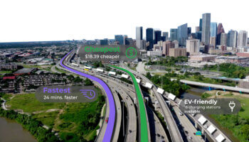
Route Optimization with TollGuru API: Fastest, Cheapest, and EV-friendly Journeys The future of mobility is digital, and the key to this future lies in harnessing the power of data.

Read More
Integrate TollGuru Toll API with TMS platforms to add toll, cost and route intelligence.

Toll API for an edge over your TMS competitors

A toll intelligent TMS can help a trucker save $69 with just 16 minute detour in a city with extensive tolls like NY. Here are the other features that Toll API can add to your TMS for a competitive edge.

Read More
Dealing with rental car toll charges in US can be an expensive and confusing mess.

How to Make Rental Car Toll Charges a Less Expensive Mess

A $3 toll can be billed as a $20 rental car toll receipt. But when you know how tolls work for rental cars, you can find the optimal ways to reduce toll costs.

Read More

Latest News in Tolling, Mapping, and Trucking

cta_desktop-min

Ready to integrate Toll Intelligence?

Get started with TollGuru Toll API or Cloud Services